|
|
 | 4. | Methods of Information Acquisition for Planning
(Measurements, Wind Tunnels, Numerical Modelling) |
| | | |
 4.1 Measurements 4.1 Measurements |
Stationary measurement and observation networks, such as the synoptic climatology network of the German Weather Service or the German federal states" Measurement Network for Air Monitoring, were devised for purposes other than urban climatology and urban planning. In order to examine small-scale compositions and variations in climate or air conditions, specialized measurement and recording methods must therefore be developed.
As far as possible, measurement stations within existing networks should be utilized, since as a rule long-term data from these stations are already available, while the periods of measurement for special studies are usually limited. Thus it is possible to adapt temporary measurements to existing series of long-term measurements.
The German Meteorological Service (DWD) runs 170 full-time climate stations, which are complemented by more than 2,500 secondary climate and precipitation stations. These and almost 1,500 other phenological observation points as well as weather radar, aerological stations and measuring stations for radiation and ozone form the basis for the collection of all kinds of meteorological data. This density of weather stations makes the DWD one of the most reliable meteorological services in Europe.
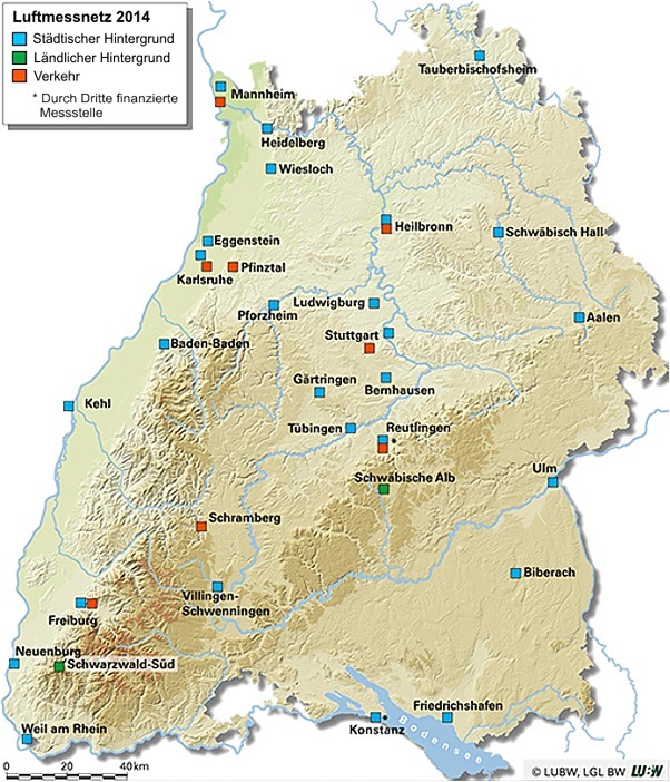
Existing measurement networks on the Länder level are also available for air measuring stations. Baden-Württemberg runs 36 fully automatic stations (2014); among them are 26 stations in urban areas, 2 in rural areas and 8 traffic stations. Their data is collected and analysed by the State Institute for Environment, Measurements and Nature Conservation Baden-Württemberg (LUBW) in Karlsruhe (see Figure 4/1).
The Federal Environment Agency (UBA) has its own monitoring network with stations in e.g. Rottenburg and at the Schauinsland mountain near Freiburg.
|
|
|